“Sviluppiamo applicazioni di web-mapping innovative e open-source”
Crediamo che le informazioni geospaziali integrate insieme a strumenti semplificati di analisi spaziale in piattaforme open-source e applicazioni di web-mapping, possano aiutare le persone a prendere decisioni migliori in grado di influenzare la propria qualità della vita, la società e il mondo in cui viviamo.
Come alternativa ai pacchetti commerciali di web-mapping, le soluzioni open-source stanno divenendo sempre più popolari negli ultimi anni e sono preferite dagli sviluppatori di GECOsistema per applicazioni di web-mapping interattive.
GECOsistema ha sviluppato tutti i propri Prodotti ricorrendo ad una piattaforma di web-mapping di tipo open-source e sfruttando la potenza di calcolo del cloud.
GECOsistema sviluppa applicazioni dedicate sia per software GIS commerciale come ESRI, sia su piattaforme open source: MapServer e GeoServer come mapping engine; MySQL, SpatiaLite e PostgreSQL / PostGIS per i database; OpenLayers per le funzionalità delle mappe nei browser, R and Python GDAL per le routine di spatial geo-processing.
Web-Mapping
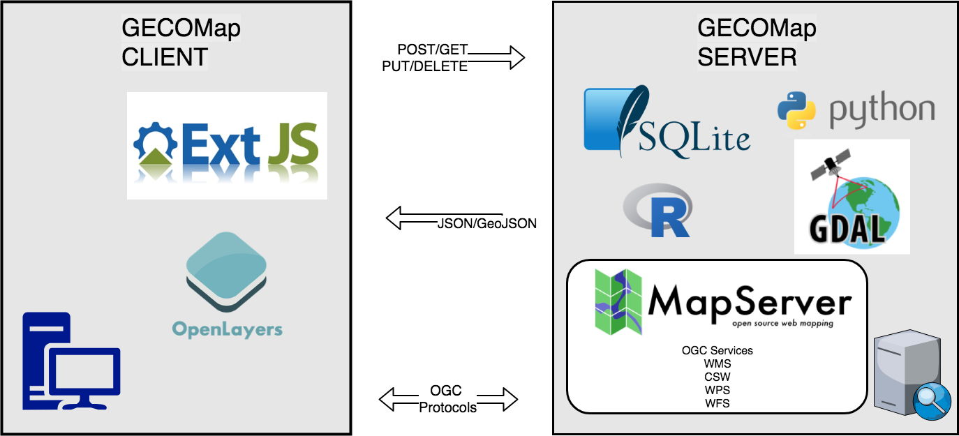
GECosistema ha sviluppato GECOMap, una piattaforma flessibile e completa per sviluppare applicazioni di web-mapping dove pubblicare on-line i propri dati spaziali e sviluppare sia semplici che complesse analisi spaziali. GECOMap è sviluppato sfruttando le librerie Python/Numpy/GDAL e il set completo di RIA-oriented JavaScript toolbox, a JavaScript testing environment, and tools for compressing JavaScript code. Il JavaScript toolbox è costituito da Sencha/ExtJS, OpenLayers, GeoExt JavaScript toolkits.
GECOMap rispetta gli standard di Open Geospatial Consortium.
Desktop GIS
GECOsistema offre e sviluppa soluzioni software di analisi spaziale e geomatica in ambiente GIS desktop (Qgis and ArcMap).
Il nostro team di IT può aiutarti nel:
- definire l’architettura delle tue soluzioni GIS e consigliarti su come svilupparla
- implementare nuove applicazioni personalizzate in piattaforme Open-source
- generare specifici layers informativi che siano di supporto al tuo business (gestione delle reti idriche, quantificazione impatti ambientali, localizzazione ottimale, etc)
- trasferimento di know-how sull’uso del Open Source GIS e sullo sviluppo di Plug-in specifici
The purpose of the assessment is to ensure that decision makers consider the environmental impacts when deciding whether or not to proceed with a project. The International Association for Impact Assessment (IAIA) defines an environmental impact assessment as “the process of identifying, predicting, evaluating and mitigating the biophysical, social, and other relevant effects of development proposals prior to major decisions being taken and commitments made.”[1]
EIAs are unique in that they do not require adherence to a predetermined environmental outcome, but rather they require decision makers to account for environmental values in their decisions and to justify those decisions in light of detailed environmental studies and public comments on the potential environmental impacts.
Strategic environmental assessment (SEA) is a systematic decision support process, aiming to ensure that environmental and possibly other sustainability aspects are considered effectively in policy, plan and programme making. In this context, following Fischer (2007)[1] SEA may be seen as:
- a structured, rigorous, participative, open and transparent environmental impact assessment (EIA) based process, applied particularly to plans and programmes, prepared by public planning authorities and at times private bodies,
- a participative, open and transparent,possibly non-EIA-based process, applied in a more flexible manner to policies, prepared by public planning authorities and at times private bodies, or
- a flexible non-EIA based process,applied to legislative proposals and other policies, plans and programmes in political/cabinet decision-making.
Effective SEA works within a structured and tiered decision framework,aiming to support more effective and efficient decision-making for sustainable development and improved governance by providing for a substantive focus regarding questions, issues and alternatives to be considered in policy, plan and programme(PPP) making.
SEA is an evidence-based instrument, aiming to add scientific rigour to PPP making, by using suitable assessment methods and techniques.
From 2005-2007, the effect of the directive was assessed. In 2010, a revised wording was published, integrated with 6 other European directives regulating large industrial sites, into the Industrial Emissions Directive, short IED.
PHOTOGALLERY


