AI-based cloud-web platform for mapping flood hazard over large areas at global scale
SmartFLOOD AI-based technology delivers Large-scale and High resolution Flood Hazard Maps at lower cost respect the standard hydrodynamic modeling approaches.
SmartFLOOD is an innovative Artificial Intelligence Cloud-Web platform developed to drastically reduce cost and processing time in mapping Fluvial Flood Hazard at large-scales and at high resolution anywhere in the world.
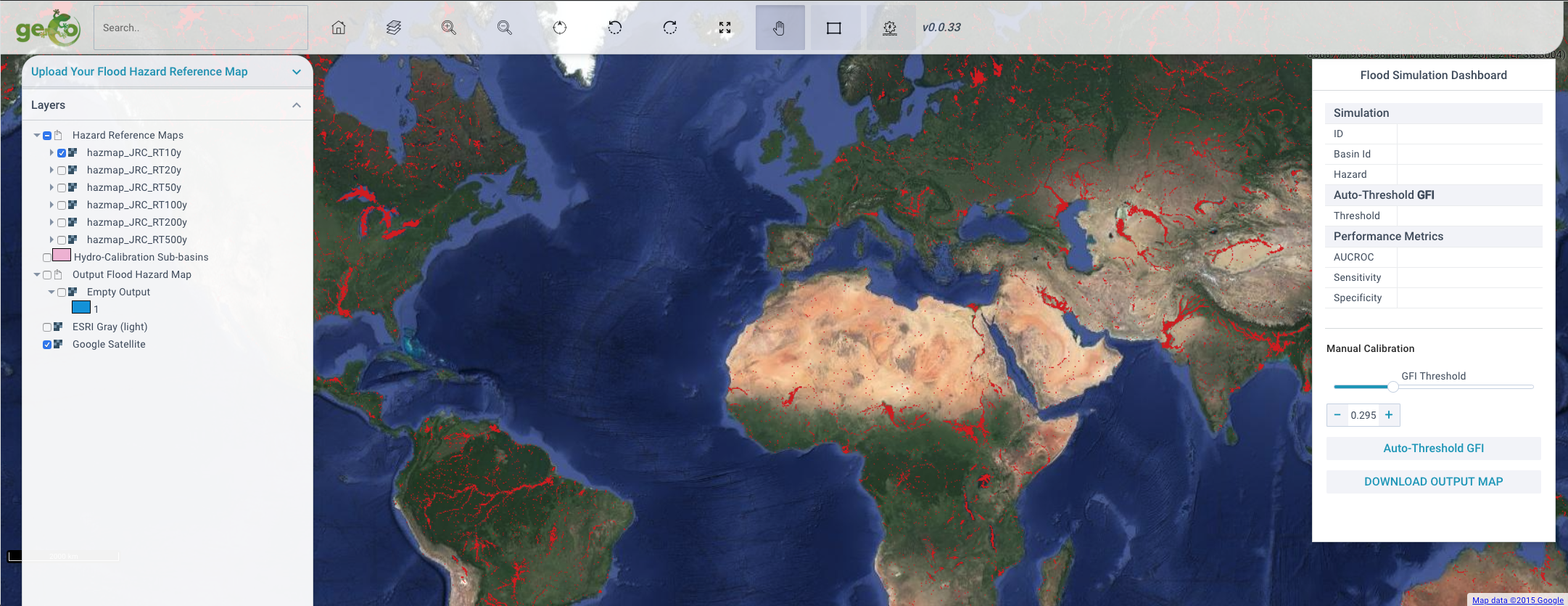
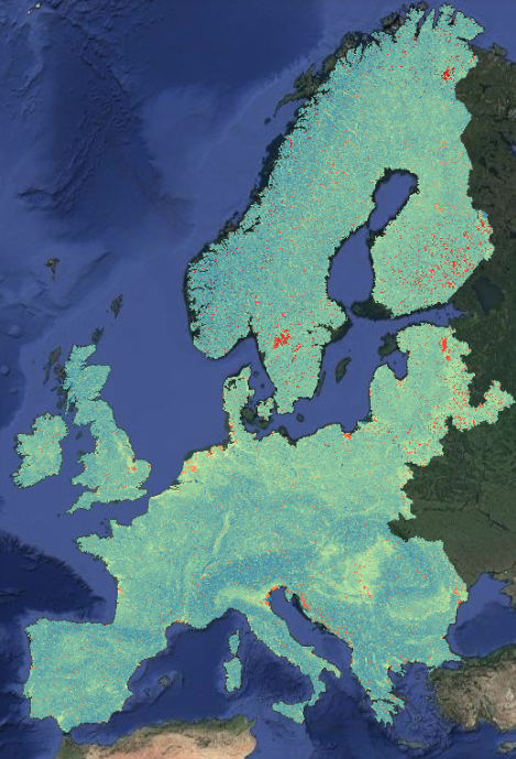
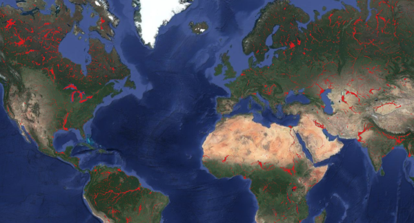
SmartFLOOD generates in in real-time comprehensive flood hazard map for every place in Europe (at 25 m resolution) and for the entire planet (at 90 m resolution).
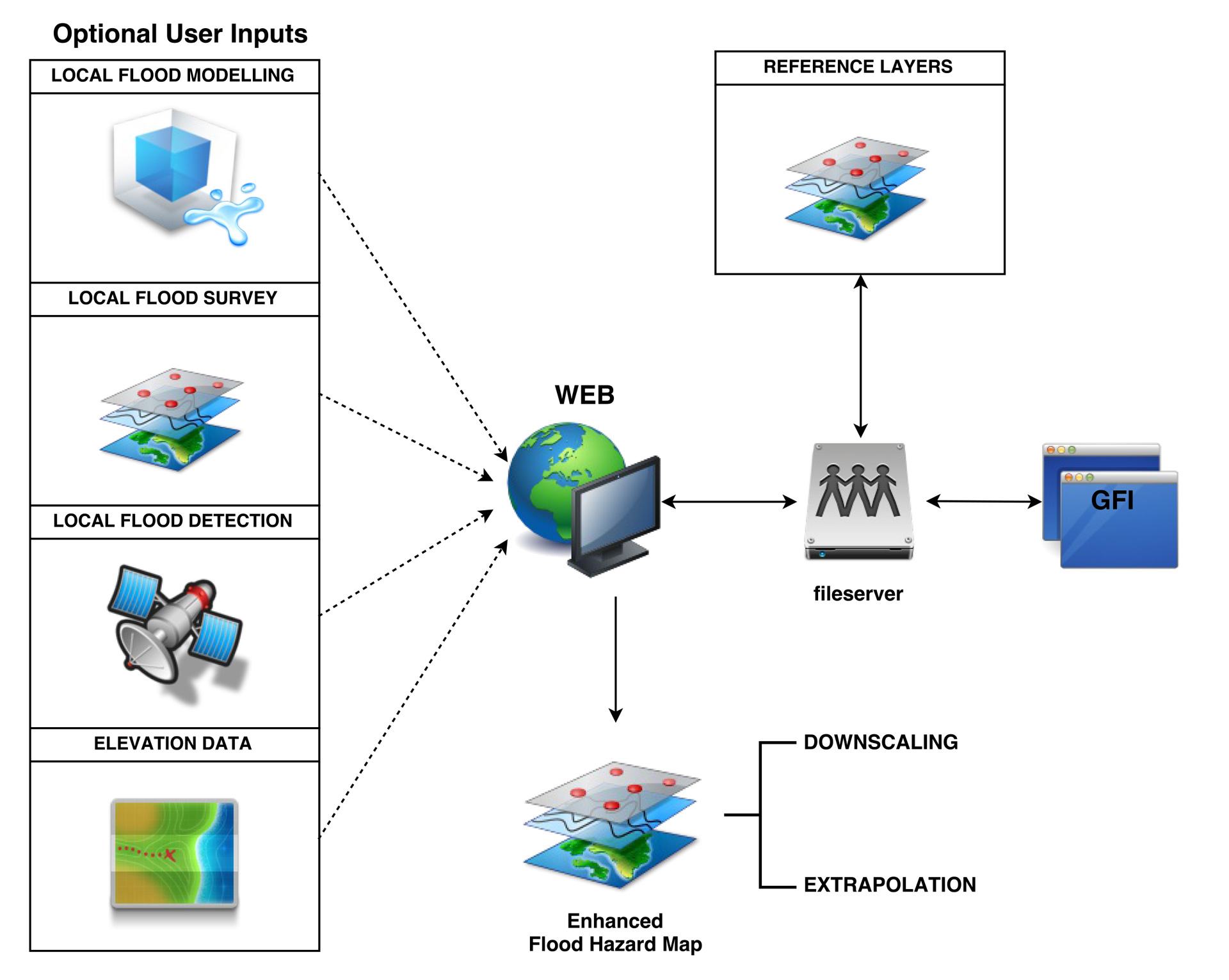
SmartFLOOD requires as unique input an available flood hazard binary reference maps provided by the user. This maps can be selected among a list of available flood hazard maps or uploaded directly by the user as results of : hydrodynamic modeling studies, on-site surveys or delineated from satellite products
SmartFLOOD integrates large scale and high resolution open data and artificial intelligence algorithms for supporting robust evidence-based decision-making in flood risk management.
The SmartFLOOD’s results consist in an extrapolation to wider areas and a downscaling to higher spatial resolution.
SmartFLOOD intelligence is composed by three main components:
- An high resolution Geomorphic Flood Index – GFI generated by processing available high resolution and hydrologically corrected Digital Elevation Models.
- A set of available benchmark flood hazard maps usually available at lower resolution or limited spatial extension.
- An efficient Machine Learning binary classification algorithm able to quickly provide the calibrated flood prone area
Calibrating the GFI threshold for a specific area of interest over an available flood hazard reference map, provided by existing flood hazard maps or numerical hydrodynamic simulations uploaded by the user in the platform;
SmarFLOOD firstly enables the capability to extend informations of existing flood areas to uncovered regions (for example from a sub-basin to the entire hydrological basin) secondly to downscale at higher resolution, up to 25 m, the available flood hazard reference maps.
The Web Service is designed to provides end-users with the possibility to consistently and cost-effectively extend local detailed flood studies (i.e. those coming from complex flood models, field studies or remote sensing detection) in uncovered data-scarce regions, to extrapolate them to larger scales and downscale to finer resolutions.
The service is fully operative and actually covers the entire PAN-EU and will be extended soon to be operative worldwide.
The Demo Version is available for free with some limitation in terms of area and resolution at the following web address :
Recently published paper Tavares et al. “A web application for hydrogeomorphic flood hazard mapping, Environmental Modelling and Software” (2019), doi: https://doi.org/10.1016/j.envsoft.2019.04.010.
SmartFLOOD is available free-of-charge with limitations for some areas prior user registration.
The fully operation of SmartFLOOD requires annual payments (“Annual Subscription Fee”) for each SmartFLOOD Zones of interest (EU NUTS Level 1 Regions for PAN-EU and Hydro-basins for Global version).
The Annual Subscription give access to SmartFLOOD platform without any limitation for the acquired SmartFLOOD Zones for 1 year.
The User can use the AI-cloud-based platform for infinite running and calibration with the possibility to upload personalised Flood Hazard Reference Maps and Download the Flood Hazard Output Maps.
Please CONTACT US for more details about Annual Subscription Costs (EURO – VAT Excluded) for each SmartFLOOD Zones.
SMARTFLOOD PAN-EU VERSION
SMARTFLOOD GLOBAL VERSION
SMARTFLOOD provides to Insurance and reinsurance companies detailed information about areas and assets prone for defining of flood risk transfer schemes.
SMARTFLOOD covers the needs of Public Authorities seeking for a comprehensive, cost effective and homogeneous mapping of large areas to meet the EU Water Framework Directive requirements.
SMARTFLOOD attends to the needs of single users seeking for local high detailed maps in data scarce regions where numerical modeling may not be feasible.

How SmartFlood Hazard Map area generated?
SMARTFLOOD core algorithm is based on the morphological descriptor Geomorphic Flood Index (Samela et al., 2017), GFI, and its use as a AI-based linear binary classification feature (Degiorgis et al., 2012).
The GFI is generated by processing available Digital Elevation Model -DEM, EU at 25 m resolution and Global at 90 m resolution (Merit HYDRO), the workflow starts with terrain analysis (i.e. determination of flow direction, local slope and upslope contributing area) of a Digital Elevation Model (DEM), using a tailored version of TauDEM tools.
SMARTFLOOD requires as unique input a binary benchmark Flood Hazard Map usually provided by numerical hydrodynamic simulations (ex. JRC LisFlood), satellite classification (Copernicus Sentinel 1) or on-site survey.
The AI-based supervised classification of the GFI is then performed within the classification area established for each river basin, searching for the optimal threshold that better represents the binarized reference flood extents.
The optimal threshold is subsequently used to segment the GFI layer, resulting in an index-based flood extent map (i.e., all values above or equal to the threshold are flagged as flooded and below as not flooded), or map of flood-prone areas.
Finally, we quantify how well suited the continuous classifier is and how well the classification performed within each, and across, river basins.
Which are the advantages of SMARTFLOOD outputs?
SMARTFLOOD Flood Hazard maps generated from an available Flood Hazard benchmark reference map area characterised by the following two main improvements respect the available data-set:
- EXTRAPOLATION: The new classified flood hazard map is an extension of the reference map covering for example un-studied areas or a more detail in terms of river representation
- DOWNSCALING: The results is produced at 30 m resolution in EU and 90 m resolution globally, this resolution is higher respect the available reference maps.